POLDER I-II and POLDER/PARASOL instruments
The POLDER instruments consist of a digital camera with a 274×242-pixel CCD detector array, wide-field telecentric optics and a rotating filter wheel enabling measurements in 9 spectral channels with bandwidths between 20nm and 40nm. Because it acquires a sequence of images every 20 seconds, the instrument can observe ground targets from different view directions. The POLDER I-II instruments onboard ADEOS 1 and 2 are identical while the instrument on the PARASOL platform has been turned 90 degrees to favor multidirectional viewing (maximum of 16 directions compared to 14) over daily global coverage (swath of 2400 km compared to 1600 km). Depending on the altitude of the platforms, the size of the images varies from 2400 x 1800 km2 to 1600 x 2100 km2 with a corresponding ground resolution of 7×6 km2 and 5.3×6.2 km2 at nadir. The PARASOL platform is part of the A-Train and takes advantage of the other instruments in the constellation. The 3 instrument spectral coverage ranges from blue (443µm) through near-infrared (0.91µm) with 3 polarized spectral bands. For POLDER/PARASOL, the bluest polarized channel has been moved from 0.443µm to 0.490µm and a 1.02 µm waveband has been added.
GRASP (Generalized Retrieval of Atmosphere and Surface Properties) algorithm is designed to retrieve complete aerosol and surface properties globally. In order to achieve reliable retrieval from satellites observations even over very reflective desert surfaces, the algorithm was designed as simultaneous inversion of a large group of pixels within one or several images. Such, multi-pixel retrieval regime takes advantage from known limitations on spatial and temporal variability in both aerosol and surface properties. Specifically the variations of the retrieved parameters horizontally from pixel-to-pixel and/or temporary from day-to-day are enforced to be smooth by additional appropriately set a priori constraints. This concept provides satellite retrieval of higher consistency. The details can be found in the articles by Dubovik et al., 2011, 2014, 2021 and in the technical documentation.
POLDER/GRASP aerosol and surface date product
Note: AERIS/ICARE Data and Services Center is official distributor of POLDER Level-1 and Level-2 data that are available at: http://www.icare.univ-lille1.fr . Additionally, the ICARE system allows the user to dive into the data using a web tool, which plots online the results. At the same time, POLDER/GRASP retrieval provided at AERIS/ICARE have somewhat different format and there is a delay placing final results at AERIS/ICARE website. Therefore, in case of difficulties we suggest to contact us for the help in identifying the best data for intended application.
There are four archives of POLDER data processed by GRASP:
POLDER-3/PARASOL
(1) PARASOL/GRASP «optimized» (in the sense that radiative transfer calculations were optimize to best tread-off between speed of processing and accuracy of results);
(2) PARASOL/GRASP «high-precision» (the accurate radiative transfer calculations were used).
(3) PARASOL/GRASP «models» (the aerosol is assumed as external mixture of several aerosol components).
(4) PARASOL/GRASP «components» – Index of refraction of aerosol particles is modelled using an internal mixture (Maxwell Garnett effective medium approximation) of different chemical components and the retrieved parameters include aerosol size distribution together with volume fractions of the assumed components (Li et al., 2019).
POLDER-1
- POLDER-1/GRASP «models» (the aerosol is assumed as external mixture of several aerosol components).
POLDER-2
- POLDER-2/GRASP «models» (the aerosol is assumed as external mixture of several aerosol components).
Retrieval specifications:
The «optimized» and «high-precision» are different only by the precision of RT calculations, while conceptually they are the same: aerosol size distribution, spectral values of complex index of refraction, fraction of spherical particles and height of aerosol, and the spectral parameters of surface BRDF and BPDF parameters are retrieved simultaneously. The retrievals were performed using one aerosol component model with 5 size bins size distribution and spectrally dependent complex refractive index. The aerosol vertical distribution was modelled using exponential profile and scale height retrieved.
The «models» approach uses different assumption for modeling aerosol properties (surface properties model is the same): the aerosol is assumed as external mixture of several aerosol components and only concentrations are retrieved together with spectral parameters of surface BRDF and BPDF. The GRASP/components approach uses MG mixing rules for modeling aerosol properties: the aerosol is mixtures of hydrated soluble particles embedded with black carbon, brown carbon, iron oxide and other non-absorbing insoluble inclusions. The volume fractions of the components are derived with the size distribution, fraction of spherical particles, height of aerosol and spectral parameters of surface BRDF and BPDF parameters. The complex refractive indices (CRI) of the dry components are fixed and the CRI of the mixture are computed based on the MG mixing rules intermediately.
The POLDER-3 data for «optimized» and «high-precision» archives were processed using GRASP v0.6.5 while v0.8.0 has been used for processing POLDER-1,-2 and -3 with GRASP «models» approach. The «components» archive was also processed using GRASP v0.8.0. The full list of the retrieved parameters, as well as additional characteristics derived from retrieved parameters, can be found in the product list provided below. The further details of the retrieval settings can be provided by a request.
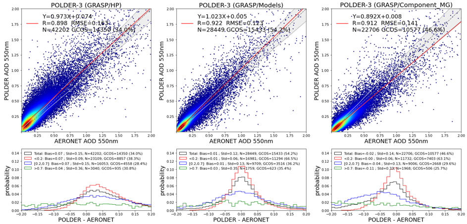
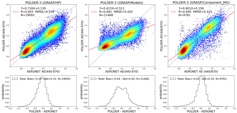
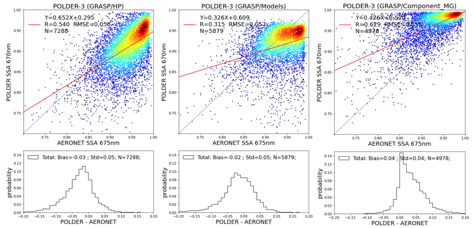
The results from «optimized» and «high-precision» processings are similar (the same set of parameters is retrieved), however the analysis and validation against AERONET showed that «high-precision» overall provide more accurate retrievals (especially for coarse mode dominated aerosols as dust) and, therefore, these data can be considered as recommended for the users. The «models» is different and retrieves directly less parameters, however in the output it provides practically the same output (the aerosol parameters that are not retrieved directly are calculated based on the used assumption of aerosol external mixture). The comparisons and validation showed that overall «models» provides very consistent results with both «optimized» and «high-precision» approaches, while it shows better performance compare to «optimized» and «high-precision» results total AOD over land. Specifically, in comparison with AERONET, both «optimized» and «high-precision» results contained notable bias over land (overestimation) for low AOD and some underestimation of total AOD for high AODs, while «models» results do not have those biases (note that no bias correction was applied for any of GRASP retrievals). At the same time, «optimized» and especially «high-precision» results showed better performance for such aerosol parameters as Angstrom Exponent and spectral SSA.
Recommendation for POLDER-3/PARASOL data users:
- If only total spectral AOD values are of interest: the «models» and «components» results are recommended
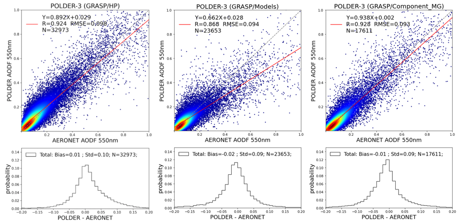
- If only Angstrom Exponent and fine and coarse spectral AOD values are of interest: the «high-precision » and «components» results are recommended
- If only spectral SSA values are of interest: the «high-precision » results are recommended, «components» also can be considered
The illustrations supporting the above information are in the section ‘Results and validation’ below.
The post-processing
The raw results files from GRASP contains three months of data of small regions (162×162 pixels). For the convenience of the users, the daily global files were created as well as their aggregates in time and space. Only the most reliable and demanded data were exported for final public distribution. Data format of this public archives is NetCDF.
In order to assure higher quality of the data, some post-processing was applied in order to eliminate the low quality points resulted from cloud contamination, bad surface description near the coast, etc. The post-processing screening follows these steps:
- First, from raw GRASP output we create global daily files. We call them level 1.
- Pixels with AOD443 > 10 are removed.
- The coast is removed so all pixels with land percent between 1 and 99 are removed. Also, to guarantee a proper coast elimination, the first pixel into ocean and land is removed.
- We remove unphysical values like water surface model over land and the other way around.
- We apply a criteria over to screen bad pixels (retrieval error is high so we remove completely the pixel):
- ocean → (residual <= 0.13) # In case of “models” archive the threshold for residual is 0.3
- land:
- If precondition ndvi < 0.1
- if (dhr670 >= 0.3) then
- if (AOD670<1)
then (residual <= 0.04) # In case of “models” archive the threshold for residual is 0.06 - else (residual <= 0.06) # In case of “models” archive the threshold for residual is 0.08
- if (AOD670<1)
- (dhr670 < 0.3) -> (residual <= 0.07) # In case of “models” archive the threshold for residual is 0.09
- if (dhr670 >= 0.3) then
- precondition 0.1 <= ndvi < 0.4
- (dhr670 >= 0.25) -> (residual <= 0.075) # In case of “models” archive the threshold for residual is 0.095
- (dhr670 < 0.25) -> (residual <= 0.085) # In case of “models” archive the threshold for residual is 0.105
- precondition 0.4 <= ndvi < 0.6
- (residual <= 0.1) # In case of “models” archive the threshold for residual is 0.12
- precondition 0.6 <= ndvi < 1
- (residual <= 0.12) # In case of “models” archive the threshold for residual is 0.14
- If precondition ndvi < 0.1
- Extra filter applied only to “models” archive: If any DHR value is missing or DHR(443) < 0, we remove entire pixel (usually snow contamination)
- The «components» archive is postprocessed using the same filtering criteria as for the «models» archive
The date passed all above filter files are stored under level 1.5. These data are not publicly available, but can be provided by a special request. This archive ensure good surface retrieval but quality of aerosol products is not guaranteed.
Then,
- the outliers are screened analyzing groups of 20×20 pixels and iteratively we remove the worst pixel (farther to the mean of AOD870) if the group does not fulfil the following condition “std of data <= 1.5 AND std / mean of data <= 0.5”. If the result group has less than 60 pixels it is completely removed (noisy area probably due to cloud contamination).
- Some aerosol products can only be calculated when there is some aerosol loading (otherwise it is difficult to measure them). So, we apply extra filters. Angstrom Exponent is only provided if AOD560 is higher than 0.02 over ocean or 0.2 over land. Other more complex products (SSA, Re(m), Im(m), AAOD,Size distribution,SphereFraction) are strongly filtered:
- land: AOD443 >= 0.3 and 0.65 <= SSA <= 1.
- ocean: AOD443 >= 0.02 and 0.65 <= SSA <= 1.
- These results are exported as level 2. Level 2 is also temporally aggregated. The temporal aggregation pixels are removed if AOD443>4.
Level 3 is created as regridding products at 0.1 and 1 degrees resolution in WGS84 projection of data available in level 2. In the regridding process we applied median filter instead of average or any other sophisticated filter.
POLDER-3/PARASOL
SSA in v1.1 and 1.2: For aggregation to 1 degree, the following strategy was used for the SSA: SSA(1 degree, Level 3)=Sum(SSA(0.1 degree Level 2)*TAU(0.1 degree Level 2)/(SumTAU(0.1 degree Level 2)
AAOD:
- v.1.1: AAOD(1 degree)=Sum(AAOD(0.1 degree Level 2))/N, where N is a number of 0.1 degree Level 2 pixels used in the Sum.
- v.1.2: AAOD(1 degree, level 3)=AOD(1 degree, level 3)* (1-SSA(1 degree, level 3))
- v.2.X: AAOD(1 degree, level 3)= Sum(AAOD(0.1 degree Level 2))/N, where N is a number of 0.1 degree Level 2 pixels used in the Sum.
NOTE: for using SSA for v.2.X, it is advice to recalculate AAOD(1 degree, level3) as: AAOD(1 degree, level 3)=AOD(1 degree, level 3)* (1-SSA(1 degree, level 3))
- In summary, the following data sets are prepared:
Level 0: raw results from grasp
Level 1: daily files from the output
Level 1.5: data softly screened. All surface pixels are good but we cannot guarantee the quality of aerosol information
Level 2: Full resolution data filtered and aggregations (daily, monthly, yearly, seasonal, and climatologically monthly, seasonal and full archive).
Level 3: Regrid at 0.1 and 1 degree of level 2 (including temporal aggregations).
Only levels 2 and 3 are publicly available since levels – 0 to 1.5 are considered internal files results of intermediate processings. Climatological monthly aggregation is the aggregation of all Januarys, Februaries, … in the archive, as seasonal climatology is all winters, all springs, …. .
POLDER-1 and -2 : The post processing was performed in exactly the same way was for POLDER-3/PARASOL “models” approach.
Note: this post-processing might now be fully adequate for POLDER-1 and -2 have some instrumental differences with POLDER-3. Based on the preliminary analysis it is suggested to apply additional screening criteria: residual <= 0.1 (over ocean) and residual <= 0.05 (over land), DHR(670)> 0. In a case of high interest to the data, please, contact us and request for optimized post-processing.
The access to the internal archive could be provided under request. Please, contact us for further information.
Any publication, presentation, or other derivative work based on these results shall acknowledge its use. Example of acknowledgment:
For PARASOL/GRASP «optimized»:
The authors would like to acknowledge the use of POLDER data "POLDER/PARASOL Level-1 data originally provided by CNES (http://www.icare.univ-lille1.fr/) processed at Laboratoire d'Optique Atmosphérique with GRASP software (https://www.grasp-open.com) developed by Dubovik et al. (2011, 2014).
Short credit: "Credit: CNES/GRASP/LOA"

For PARASOL/GRASP “high-precision”:
The authors would like to acknowledge the use of POLDER data "POLDER/PARASOL Level-1 data originally provided by CNES (http://www.icare.univ-lille1.fr/) processed at AERIS/ICARE Data and Services Center with GRASP software (https://www.grasp-open.com) developed by Dubovik et al. (2011, 2014).
Short credit: "Credit: CNES/GRASP/LOA/ICARE"

For PARASOL/GRASP “models”:
The authors would like to acknowledge the use of POLDER data "POLDER/PARASOL Level-1 data originally provided by CNES (http://www.icare.univ-lille1.fr/) and AERIS/ICARE Data and Services Center, processed by Cloudflight Austria GmbH with GRASP software (https://www.grasp-open.com) developed by Dubovik et al. (2011, 20114).
Short credit: "Credit: CNES/GRASP/LOA/Cloudflight/ICARE"

For PARASOL/GRASP “Components”:
The authors would like to acknowledge the use of POLDER data "POLDER/PARASOL Level-1 data originally provided by CNES (http://www.icare.univ-lille1.fr/) and AERIS/ICARE Data and Services Center, processed by Cloudflight Austria GmbH with GRASP software (https://www.grasp-open.com) developed by Dubovik et al. (2011, 2014, 2021) and Li et al. (2019). Short credit: "Credit: CNES/GRASP/LOA/Cloudflight/ICARE"

For POLDER-1 and -2/GRASP “models”:
The authors would like to acknowledge the use of POLDER data "POLDER/PARASOL Level-1 data originally provided by CNES (http://www.icare.univ-lille1.fr/) and AERIS/ICARE Data and Services Center, at Laboratoire d'Optique Atmosphérique with GRASP software (https://www.grasp-open.com) developed by Dubovik et al. (2011, 20114), Post-processed with help of Cloudflight Austria GmbH. Short credit: "Credit: CNES/GRASP/LOA/Cloudflight/ICARE"