
TROPOMI/Sentinel-5p Instrument
Tropospheric Monitoring Instrument (TROPOMI) aboard the Sentinel-5 Precursor (S5p) satellite was launched on 13 October 2017. TROPOMI instrument provides hyperspectral measurements in ultraviolet (UV), visible (VIS), near (NIR) and shortwave (SWIR) infrared spectral range. Though the main purpose of the instrument is trace gas characterization, it is also capable of aerosol and surface characterization. In particular, TROPOMI measurements in UV have unique information about absorption and elevation properties of aerosol. Moreover, measurements in a wide spectral range and wide sawath are very sensitive to aerosol size and surface BRDF.
GRASP Retrieval Specifications
In the framework of ESA S5p+Innovation AOD/BRDF project (https://www.grasp-sas.com/projects/aod-brdf_sentinel-5p-innovation/), the GRASP (Generalized Retrieval of Atmosphere and Surface Properties) algorithm (Dubovik et al., 2011, 2014, 2021) is adapted to the development of a product of spectral surface BRDF and aerosol information from (and for) the TROPOMI instrument. The S5p/TROPOMI GRASP aerosol and surface products contain direct retrieved aerosol and surface parameters as well as derived aerosol optical properties (spectral AOD, AODF, AODC, SSA etc.) and surface NDVI, spectral DHR (black sky albedo) and spectral BHR_iso (white sky albedo). Both aerosol and surface products are derived at spatial resolution of about 10 km and at 10 reference wavelengths (340, 367, 380, 416, 440, 494, 670, 747, 772, 2313 nm), providing possibility for extrapolations and interpolations to other spectral channels of S5p/TROPOMI measurements (Litvinov et al., 2022, in preparation; Chen et al., 2022, in preparation; TROPOMI Validation Report (VR) GRASP BRDF + AOD: issue 1.0; TROPOMI Final Report (FR) GRASP BRDF + AOD: issue 1.0).
TROPOMI/GRASP product description
The TROPOMI/GRASP product contains direct retrieved parameters as well as derived aerosol optical and microphysical properties, surface albedos and NDVI and other auxiliary parameters.
List of fields contained in the TROPOMI/GRASP product
| Name | Unit | Dimension | LongName and Description |
| aerosol_absorption_optical_thickness | 1 | (y, x, wls) | Absorption Aerosol Optical Depth |
| aerosol_angstrom_exponent_440_670 | 1 | (y, x) | Angstrom Exponent obtained from 440 and 670nm |
| aerosol_dust_mode_fraction | 1 | (y, x) | Aerosol dust mode fraction |
| aerosol_fine_abs_mode_fraction | 1 | (y, x) | Aerosol fine absorbing mode fraction |
| aerosol_fine_mode_optical_thickness | 1 | (y, x, wls) | Fine mode Aerosol Optical Depth |
| aerosol_fine_nonabs_mode_fraction | 1 | (y, x) | Aerosol fine non-absorbing mode fraction |
| aerosol_mean_height_vertical_profile | m | (y, x) | Scale height of vertical profile |
| aerosol_oceanic_mode_fraction | 1 | (y, x) | Aerosol oceanic mode fraction |
| aerosol_optical_thickness | 1 | (y, x, wls) | Aerosol Optical Depth |
| aerosol_single_scattering_albedo | 1 | (y, x, wls) | Single Scattering Albedo |
| aerosol_total_column_concentration | mkm | (y, x) | Total column volume concentration of aerosol in [mkm] |
| Datetime | s | (y, x) | Unix time in seconds from 1970/01/01T00:00:00 |
| LandPercentage | 1 | (y, x) | Percentage of land |
| Latitude | deg | (y, x) | latitude |
| Longitude | deg | (y, x) | longitude |
| quality_assurance_index | 1 | (y, x) | Quality assurance for AOD, AODF, AAOD, AerosolConcentration, DHR, BHR_ISO, NDVI, Ross_Li_BRDF_isotropic_parameter, LandBRDFRossLi_2, LandBRDFRossLi_3, Cox_Munk_iso_BRM_first_parameter, WaterBRMCoxMunkIso_2, WaterBRMCoxMunkIso_3. QA=1 (Marginal), QA=2 (Good), QA=3 (Very Good) |
| quality_assurance_index_extend | 1 | (y, x) | Quality assurance for extend aerosol properties: AExp, SSA, VertProfileHeight, AeroModelCon. QA=1 (Marginal), QA=2 (Good), QA=3 (Very Good) |
| ResidualAbsolute | 1 | (y, x) | Residual (absolute) |
| ResidualRelative | 1 | (y, x) | Residual (relative) |
| solar_zenith_angle | deg | (y, x, wls) | Solar zenith angle |
| surface_directional_hemispherical_reflectance | 1 | (y, x, wls) | Directional Hemispherical Reflectance (Black Sky Albedo) |
| surface_elevation | m | (y, x) | Meters above sea level |
| surface_isotropical_bihemispherical_reflectance | 1 | (y, x, wls) | Surface Isotropic Bihemispherical Reflectance (White Sky Albedo) |
| surface_land_brdf_rossli_geometric _normalized | 1 | (y, x) | Ross Li BRDF normalized geometric parameter |
| surface_land_brdf_rossli_isotropic | 1 | (y, x, wls) | Ross Li BRDF isotropic parameter |
| surface_land_brdf_rossli_volumetric_normalized | (y, x) | Ross Li BRDF normalized volumetric parameter | |
| surface_ndvi | 1 | (y, x) | Normalized Difference Vegetation Index |
| surface_water_brdf_coxmunk_fresnel_fraction | 1 | (y, x) | Fraction of water surface providing specular Fresnel reflection (free of whitecaps/foam) |
| surface_water_brdf_coxmunk_isotropic | 1 | (y, x, wls) | Isotropic reflectance of water body |
| surface_water_brdf_coxmunk_msq_slope | 1 | (y, x) | Mean square slope of Cox-Munk model |
| wavelength | mkm | wls | wavelength |
| x | – | x | WGS84 coordinates (easting) |
| xs | – | x | x-coordinates in segmenting space |
| y | – | y | WGS84 coordinates (northing) |
| ys | – | y | y-coordinates in segmenting space |
Recommendation for TROPOMI/GRASP data users
The best data from the dataset can be selected according to the quality assurance index:
- Quality_assurance_index
- Quality_assurance_index_extended
All pixels with Quality_assurance_index=2 or 3 guarantees good (value 2) or high (value 3) quality of the retrieval.
“Quality_assurance_index” is applied for such characteristics as: AOD, AODF (fine mode AOD), AAOD, AerosolConcentration, DHR (surface_directional_hemispherical_reflectance), BHR_ISO (surface_isotropical_bihemispherical_reflectance), NDVI, surface BRDF parameters over land and ocean (Ross_Li_BRDF_ parameters and Cox_Munk parameters).
“Quality_assurance_index_extend” can be applied to extend aerosol properties: Angstrom Exponent (AExp), SSA, VertProfileHeight, AeroModelCon.
The NetCDF files contain the description to which characteristics the quality indices are applicable.
Any publication, presentation, or other derivative work based on these results shall acknowledge its use.
Example of acknowledgment:
The authors would like to acknowledge GRASP and CloudFlight teams for GRASP/S5p datasets obtained in the framework of ESA S5p+Innovation AOD/BRDF project (https://www.grasp-sas.com/projects/aod-brdf_sentinel-5p-innovation/).
The following documents are recommended as references:
- Dubovik, O., Fuertes, D., Lytvynov, P. et al. A Comprehensive Description of Multi-Term LSM for Applying Multiple Priori Constraints in Problems of Atmospheric Remote Sensing: GRASP Algorithm, Concept, and Applications, Front. Remote Sens., doi: 10.3389/frsen.2021.706851, 2021.
- Litvinov et al., 2022. Part I (in preparation, the reference will be updated)
- Chen et al., 2022. Part II (in preparation, the reference will be updated))
- S5p+Innovation Validation Report (VR): GRASP BRDF + AOD: issue 1.0 – Final, 2021-07-11.
- S5p+Innovation Final Report (FR): GRASP BRDF + AOD: issue 1.0 – Final, 2022-03-17.
Results and validation
Figures 1-3 shows validation of S5p/TROPOMI GRASP aerosol products (AOD 550 nm, AE 412/670, AODF and SSA 550 nm) validation with AERONET measurements for one year of the products (from March 2019 till February 2020). The QA and QAExtend are used to select retrievals with good quality, for more detailed validation results, please refer to Litvinov et al. (2022, in preparation) and Chen et al. (2022, in preparation).
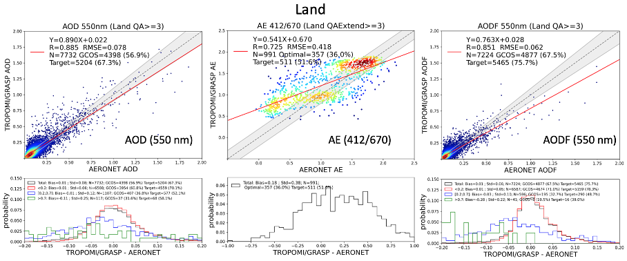
Figure 1: Validation of S5p/TROPOMI GRASP aerosol products (AOD 550 nm, AE 412/670 and AODF 550 nm) versus AERONET over land.
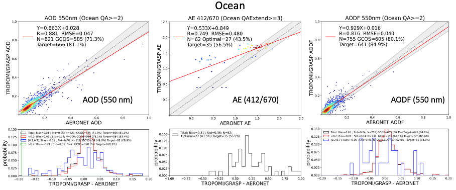
Figure 2: Validation of S5p/TROPOMI GRASP aerosol products (AOD 550 nm, AE 412/670 and AODF 550 nm) versus AERONET over ocean.
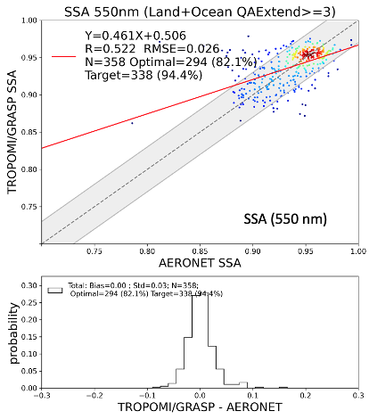
Figure 3: Validation of S5p/TROPOMI GRASP SSA (550 nm) versus AERONET.