
OLCI/Sentinel-3A Instrument
The Ocean and Land Color Instrument (OLCI) onboard the Sentinel-3A satellite is a medium-resolution and multi-spectral imager. The OLCI instrument is the follow-on mission to the Medium Resolution Imaging Spectrometer (MERIS) instrument flown on Envisat. The Sentinel-3A is on a near-polar, sun-synchronous orbit with a descending node equatorial crossing at ~10:00h Local Time (LT). The OLCI instrument adopts the “push-broom” method to scan the Earth’s surface covering the solar spectral range from 400 nm to 1040 nm, and it has a 68.5° field of view around nadir and covers a swath with of 1270 km (Sentinel-3 OLCI User Guides, https://sentinel.esa.int/web/sentinel/user-guides/sentinel-3-olci). The primary objective is to screen the ocean and land surface to obtain information related to biology, meanwhile OLCI observations are also can be used for obtaining valuable information for atmospheric aerosol and surface characterization.
Retrieval specifications
In the framework of EUMETSAT funded study to support Copernicus Programme, the GRASP (Generalized Retrieval of Atmosphere and Surface Properties) algorithm (Dubovik et al., 2011, 2014) is adapted on the development of OLCI/Sentinel-3A aerosol and surface products. The details of the project information are on https://www.eumetsat.int/science-studies/
Specifically, GRASP/Models approach (Chen et al., 2020; Lopatin et al., 2021; Dubovik et al., 2021) is used. The OLCI Reduced Resolution Level-1B (L1B RR) TOA radiances at 9 spectral channels (Oa02: 412.5 nm, Oa03: 442.5 nm; Oa04: 490 nm; Oa05: 510 nm; Oa06: 560 nm Oa08 665 nm; Oa12: 753 nm; Oa17: 865 nm; Oa21: 1020 nm) are inverted using the GRASP multi-pixel concept. In order to deal with OLCI single viewing measurements, which have no or limited sensitivity to angular features of BRDF, the OLCI/GRASP retrieval constrain the angular properties of underlying surface strongly: over ocean Fresnel reflection is fixed using a priori wind speed, and over land BRDF retrieval is constrained using a priori values for Ross-Li volumetric and geometric terms. The isotropic reflectance is retrieved both over land and ocean under mild spectral smoothness constraints.
OLCI/GRASP product description
The OLCI/GRASP V1.0 aerosol and surface products are processed based on GRASP (v1.0.0) for one year (June 2018 to May 2019) (We are going to extend our processing in the future). The daily product is contained in files typically named as:
Level 2 (10 km): GRASP_OLCI_L2_YYYYMMDD.full.nc
Level 3 (0.1 degree): GRASP_OLCI_L3_YYYYMMDD.01degree.nc
Level 3 (1 degree): GRASP_OLCI_L3_YYYYMMDD.1degree.nc
The file format is NetCDF-4. The Level 2 data is created from the raw GRASP output after merging them into global daily files and applying general filter for coastal line and pixels with high fitting residuals. The Level 2 file is at 10 km resolution under sinusoidal projection and Level 3 is created as regrided products at 0.1 and 1 degrees resolutions in equirectangular projection of data available in Level 2.
Levels 2 and 3 data are publicly available. Climatological monthly and seasonal aggregations are also provided along with the daily files.
The product post-processing procedure (i.e. quality flag) is under investigation and development.
In the files, the main aerosol parameter is AOD (). Meanwhile, we also diagnosed aerosol parameters such as: AAOD() and SSA(), which are of interest for further considerations. The main surface product is NDVI, white sky albedo DHR () and black sky albedo BHR_ISO (), and we keep diagnosed full BRDF parameters in the product file. We also provided supplementary information such as LandPercentage, relative fitting residual (ResidualRelative), absolute fitting residual (ResidualAbsolute) etc.
Recommendation for OLCI/GRASP data users
- The main OLCI/GRASP aerosol product is AOD (). To simply select high quality product, the threshold ResidualRelative < 0.01 over land and ResidualRelative < 0.1 over ocean are recommended.
- The Angstrom Exponent (AE) is generally of higher confidence over ocean than over land. The AE over bright land surface is of relatively low confidence due to the lack of information content.
- Even though the diagnosed SSA is of interest, we suggest to filter low aerosol abundance, i.e. AOD 550<0.5, together with ResidualRelative.
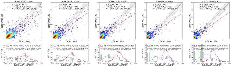
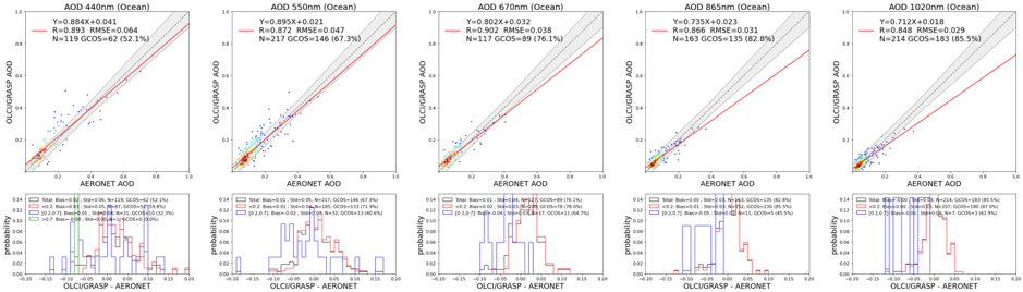
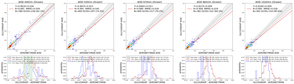
We perform one-year preliminary validation of L3 product with AERONET and MAN maritime network. The grided product is averaged in a 5×5 window centered over the AERONET sites, meanwhile the available AERONET products are averaged within a time window (30 mins for direct Sun product, and 360 mins for MAN measurements):
OLCI/GRASP spectral AOD validation over land (AERONET):
OLCI/GRASP spectral AOD validation over ocean (AERONET):
OLCI/GRASP spectral AOD validation over ocean (MAN):
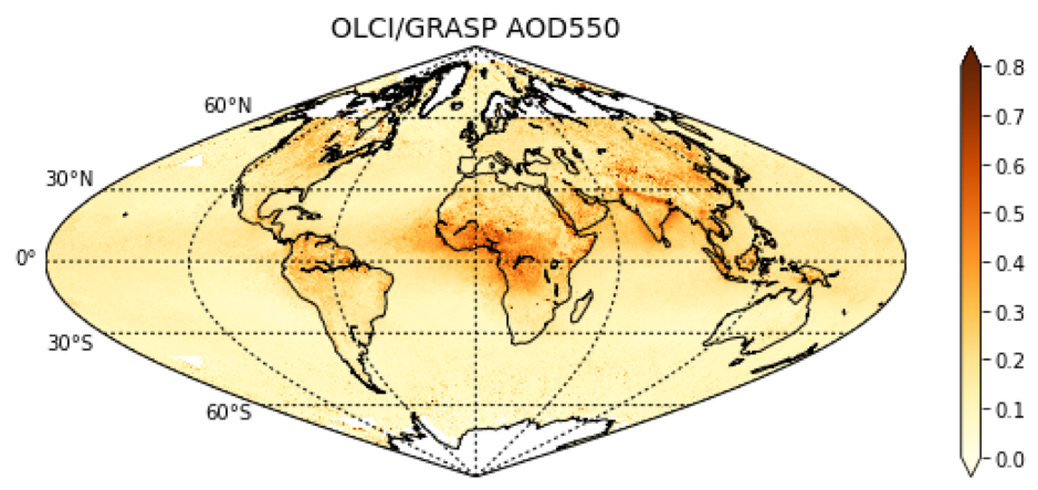
Spatial distribution OLCI/GRASP one-year (June 2018 – May 2019) global AOD 550 nm:
Please, contact us for further information.
Any publication, presentation, or other derivative work based on these results shall acknowledge its use.